New newsletter platform This email is (hopefully) finding you via my new setup on Micro.blog. So, so you’ll see a different “from” address. Most importantly, unlike before, you cannot reply directly to this newsletter to get in touch. Please write separately to hello@oldinsurancemaps.net.
Getting out and about Mapping USA: Video now on YouTube At the very end of January I co-led a workshop during OpenStreetMap US’s virtual Mapping USA conference, Historical Mapping with OpenHistoricalMap, OldInsuranceMaps.
READ MORE →
Also on Bluesky
Herein: Updates on the future of OIM, some good ol' tech improvements, new blog post, and community notes. For new readers, welcome! And here are all past newsletters in case one isn’t enough.
READ MORE →
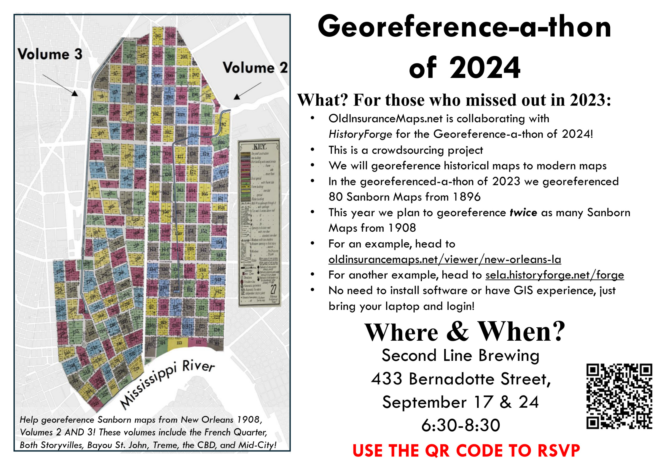
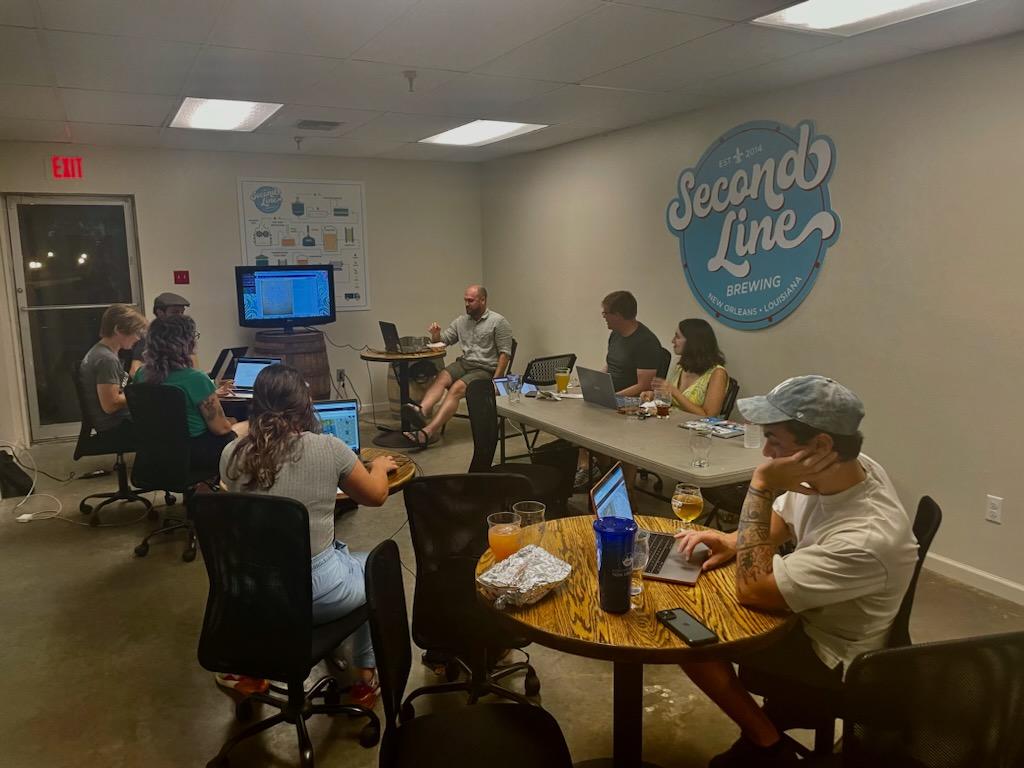
Georeference-a-thons in New Orleans Over the next couple of weeks we’ll be holding two community georeferencing events at Second Line Brewing in New Orleans. If you are in the area, we hope you can make it!
Dates: Tuesday Sept 16th & Tuesday Sept 23rd Time: 6:30-8:30pm Location: Second Line Brewing, 433 N Bernadotte St RSVP Form: https://tiny.cc/georef-2025 As we have in the past, we’re doing these events in collaboration with the Midlo Center and HistoryForge.
READ MORE →
Hello all! Writing to tell you about a few things that have happened in the last few months, and some upcoming news.
For new readers: Welcome! You can find all past newsletters in the archive. You can also respond directly to this email to say hello, and you’ll find an unsubscribe link below.
Online presentation for I-GUIDE VCO series, tomorrow! Wednesday 7/16, 11am US Central Time – registration link
Apologies for the late notice.
READ MORE →
Hello and happy second month of the New Year! It is high Mardi Gras season here in New Orleans and I feel like everything is happening at the same time. For new readers: Welcome! You can find all past newsletters in the archive…
READ MORE →
In case you didn’t know, GIS Day this year is next Wednesday, Nov. 20th, in the middle of Geography Awareness Week. GIS Day was started by the company ESRI (of ArcGIS reknown) many years ago, and I just learned that Ralph Nader was the inspiration behind the day. Of course, there is a lot to GIS beyond Esri, but as someone who learned about the field at the end of my undergrad and never looked back, I love that GIS Day exists and consider it a great “holiday” to promote.
READ MORE →
Upcoming Georeference-a-thons! Here in New Orleans we have two public Georeference-a-thons right around the corner! On the next two Tuesdays we will be gathering at Second Line Brewing (as before) from 6:30 to 8:30pm to georeference more New Orleans Sanborn maps for HistoryForge. We did this last summer, and the resulting work has been integrated directly into the HistoryForge platform (as you can see in the link, click the map icon).
READ MORE →
Hello! The last newsletter I sent out was over half a year ago so a lot has happened in the meantime (including: I got married!). I’ll get to most of the updates here, but hopefully will be able to follow-up sooner than later with more. Before going further, I’d like to welcome the 50+ new folks who have registered since the year started. Looking forward to hearing and seeing what you work on! Which is a good segue to the next point…
READ MORE →
Hello everyone and welcome to the final newsletter of 2023! It was last January that I made an announcement letting you all know we were back in business here, and since then a lot of wonderful things have come from the project. First, a couple of recent things I haven’t yet told you about…
READ MORE →
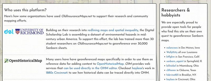
I will be presenting (virtually) to the Geography & GIScience department at the University of Illinois tomorrow, as part of the Healthy Regions & Policies Lab monthly speaker series. I’m really looking forward to this–it will largely be an introduction and summary of OldInsuranceMaps.net, but I also plan to highlight a bit of the work that the students at University of Richmond have been doing recently.
READ MORE →
Hello all! Some announcements and recaps, plus a few updates on (subtle but important) improvements to the site.
Before going further though, I’ve scheduled another georeference-a-thon at Second Line Brewing for Tuesday June 27th, 6:30pm-8:30pm! You can RSVP here: https://forms.gle/wTMtoeHR3NwzXN4q8. Also, please fill that form out if 1) you can’t make it on that day but would like to in the future, or 2) you don’t live in New Orleans but would be interested in doing an event like this in your town.
READ MORE →
I’m finally ready to send out an update about oldinsurancemaps.net… it’s been many months so I apologize for that, but I promise it’s worth the wait! Before going further, a few quick points:
I added a map viewer for each city: oldinsurancemaps.net/viewer/baton-rouge-la (other cities follow this same url pattern) New, more robust, documentation, FAQ, and blog site: about.oldinsurancemaps.net This is now a proper newsletter that you can subscribe/unsubscribe to (if you have an account on the site you are subscribed but can still unsubscribe and retain your account).
READ MORE →
Nearing the very end of this project, I have my MS thesis defense this Thursday June 30th at 3:30pm central time. You are welcome to drop in! In-person at LSU: Howe-Russell Rm. 254.
It won’t take long. I will give a short overview of the project (~5 min) (concept, research questions, results) and then there will be a public Q&A where anyone can ask questions.
In the coming weeks I’ll combine and transfer the layers that all of you created to LSU Atlas for safe-keeping, so you can expect one final update when that is underway.
READ MORE →
Tomorrow from 12:30 - 1:30pm central time, I’ll be doing a “lunch and learn” presentation about oldinsurancemaps.net to the American Planning Association – Metro New Orleans Section.
READ MORE →
It’s been a while since the last update, and I’m happy to finally be emailing you again. Only two weeks left until the end of the public participation period (more about that below). Things are going well!
READ MORE →
Hello all,
I’m writing to share with you a few updates on the Sanborn map crowdsourcing project: oldinsurancemaps.net.
This contact list consists of 1) registered participants on the site, and 2) people who have expressed interest but not registered. If you are in the latter category and would like to receive future announcements (there won’t be many), please opt-in by replying to this email with “subscribe” (or sign up! 🙂 ).
READ MORE →
I’m writing to inform you of a crowdsourcing project and research study that I believe will be of interest. This project is the basis of my MS Geography and MLIS dual degree at Louisiana State University.
READ MORE →