Stay up-to-date with OldInsuranceMaps
This feed is a compilation of newsletters, posts, presentations, and technical notes about OldInsuranceMaps.net since the project started in 2020. You can follow this feed via:
- Newsletter subscription
- BlueSky: @oldinsurancemaps.net
- Fediverse (Mastodon, etc.): @oldinsurancemaps@blog.oldinsurancemaps.net
- RSS
-
New newsletter platform This email is (hopefully) finding you via my new setup on Micro.blog. So, so you’ll see a different “from” address. Most importantly, unlike before, you cannot reply directly to this newsletter to get in touch. Please write separately to hello@oldinsurancemaps.net. Getting out and about Mapping USA: Video now on YouTube At the very end of January I co-led a workshop during OpenStreetMap US’s virtual Mapping USA conference, Historical Mapping with OpenHistoricalMap, OldInsuranceMaps. READ MORE → -
Upcoming: Mapping USA and Code4Lib
Mapping USA (January 31) This coming Saturday at 1pm CST I’ll be co-presenting in a workshop at Mapping USA, a free virtual conference organized by OpenStreetMap US. The workshop, Historical Mapping with OpenHistoricalMap, OldInsuranceMaps.net, and Yesterdays will feature demos from me, Jeff of OpenHistoricalMap, and (particularly excitingly) Jacob and Mike from the new project Yesterdays. We’ll be showing how all of these crowdsourced applications are interrelated, for example, how georeferenced maps OldInsuranceMaps. READ MORE → -
Blog migration completed! I’ve consolidated all past blog posts and newsletters into this single feed on @micro.blog , and replaced the existing blog site at blog.oldinsurancemaps.net. Looks like some strangeness remains with dates on migrated past posts, but overall, success.
-
Newsletter: Winter 2025
Herein: Updates on the future of OIM, some good ol' tech improvements, new blog post, and community notes. For new readers, welcome! And here are all past newsletters in case one isn’t enough. READ MORE → 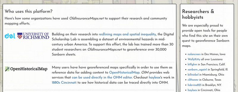
-
(Re)Introducing the MultiMask Interface
The “multimask” is a concept in OldInsuranceMaps.net that greatly eases the creation of seamless mosaics from many different georeferenced layers. I recently made some updates to the user interface for this tool, and decided to take the time to provide a better introduction to feature as a whole. READ MORE → 
-
Newsletter: Fall 2025 - Upcoming Events
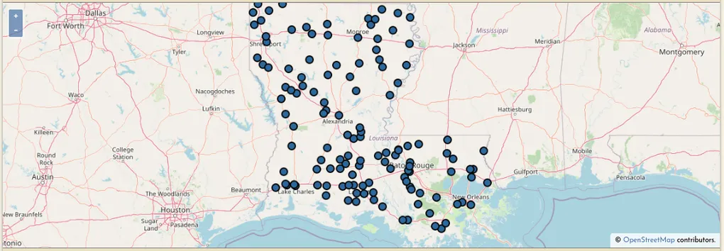
Georeference-a-thons in New Orleans Over the next couple of weeks we’ll be holding two community georeferencing events at Second Line Brewing in New Orleans. If you are in the area, we hope you can make it! Dates: Tuesday Sept 16th & Tuesday Sept 23rd Time: 6:30-8:30pm Location: Second Line Brewing, 433 N Bernadotte St RSVP Form: https://tiny.cc/georef-2025 As we have in the past, we’re doing these events in collaboration with the Midlo Center and HistoryForge. READ MORE → -
Using GDAL's VRTs for Georeferencing, from "A look inside OldInsuranceMaps.net"
Recently I gave a presentation about OldInsuranceMaps.net for I-GUIDE’s Virtual Consulting Office speaker series and I was able to talk a bit more about the technical details of the platform than I have in the past, which was really fun and a great excuse to make some more diagrams. One element of the system I described is the way that the georeferencing process relies on GDAL’s “virtual raster” driver (i.e. file format), and how this is used for, among other things, the live preview feature of the georeferencing interface. READ MORE → 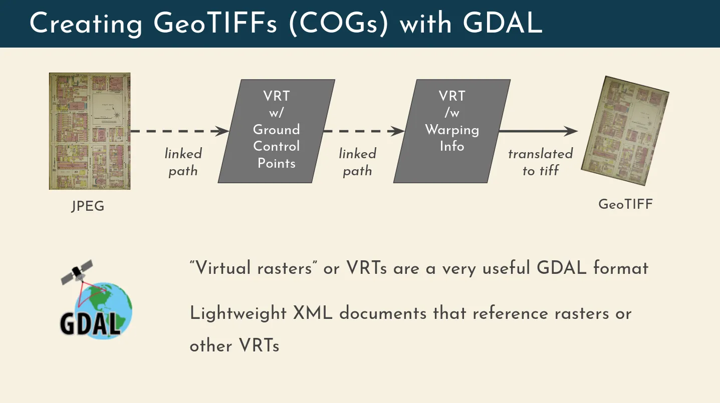
-
Newsletter: Summer 2025
Hello all! Writing to tell you about a few things that have happened in the last few months, and some upcoming news. For new readers: Welcome! You can find all past newsletters in the archive. You can also respond directly to this email to say hello, and you’ll find an unsubscribe link below. Online presentation for I-GUIDE VCO series, tomorrow! Wednesday 7/16, 11am US Central Time – registration link Apologies for the late notice. READ MORE → -
Implementing S3 Object Storage
What is S3 Object Storage? S3 object storage is a protocol developed by Amazon Web Services for handling file storage outside of a normal server environment and “in the cloud” instead. In other words, it’s a simplified way of uploading, downloading, or directly accessing files that are stored in remote “buckets”. In these buckets, storage is (broadly speaking) very cheap and practically unlimited. Many other companies have since adopted the S3 API so their own cloud storage offerings are compatible with it. READ MORE → -
Newsletter: 2024 in Review + new features!
Hello and happy second month of the New Year! It is high Mardi Gras season here in New Orleans and I feel like everything is happening at the same time. For new readers: Welcome! You can find all past newsletters in the archive… READ MORE → -
Newsletter: GIS Day Events | NACIS | Data Agreement
In case you didn’t know, GIS Day this year is next Wednesday, Nov. 20th, in the middle of Geography Awareness Week. GIS Day was started by the company ESRI (of ArcGIS reknown) many years ago, and I just learned that Ralph Nader was the inspiration behind the day. Of course, there is a lot to GIS beyond Esri, but as someone who learned about the field at the end of my undergrad and never looked back, I love that GIS Day exists and consider it a great “holiday” to promote. READ MORE → 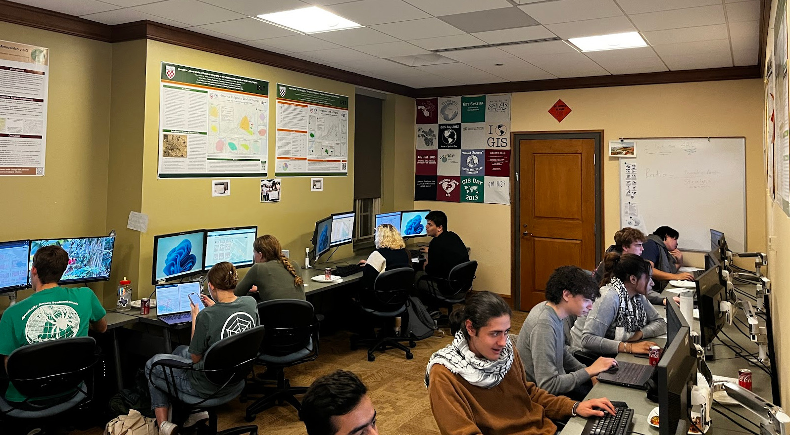
-
"Handling Complex Content within Georeferenced Historical Atlases"
Last month I traveled to the annual North American Cartographic Information Society meeting, this year in Tacoma, WA, and presented about OldInsuranceMaps.net. The video of the talk is now on YouTube: Handling Complex Content within Georeferenced Historical Atlases. You can also flip through the slides here: tiny.cc/nacis2024-ac. Even though it sounds pretty boring, this was extremely gratifying to put together and present, because it distills what I think is most unique about the platform. READ MORE → 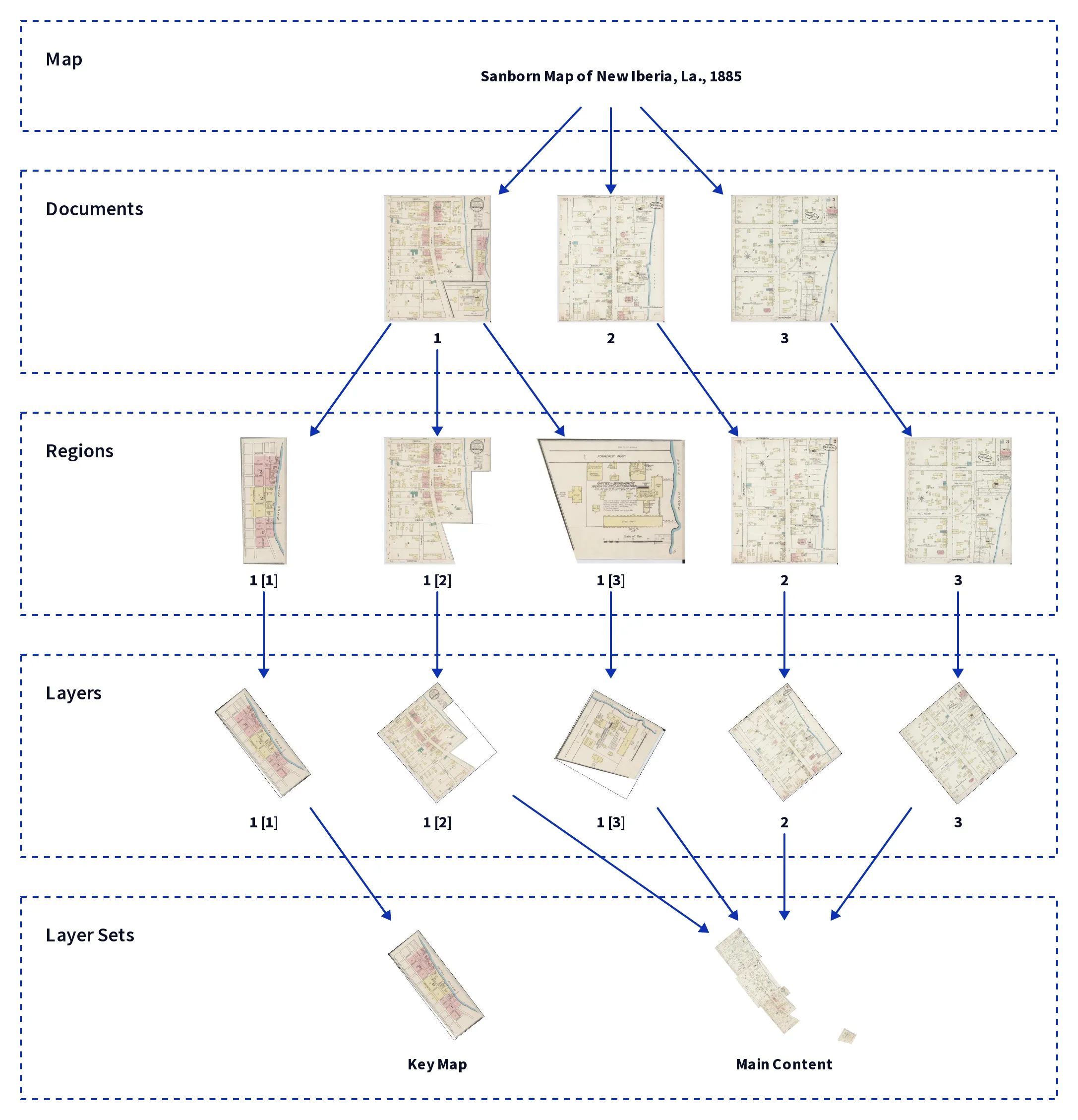
-
Newsletter: Fall 2024
Upcoming Georeference-a-thons! Here in New Orleans we have two public Georeference-a-thons right around the corner! On the next two Tuesdays we will be gathering at Second Line Brewing (as before) from 6:30 to 8:30pm to georeference more New Orleans Sanborn maps for HistoryForge. We did this last summer, and the resulting work has been integrated directly into the HistoryForge platform (as you can see in the link, click the map icon). READ MORE → 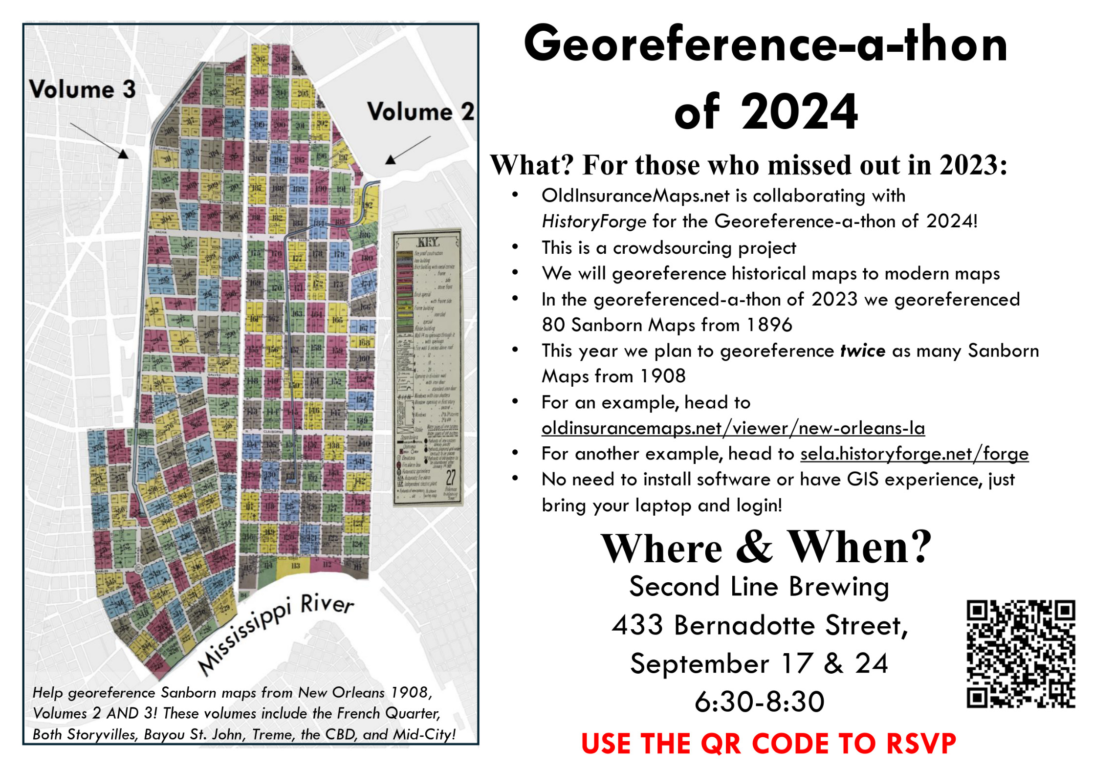
-
Newsletter: Spring and Mid-Summer Updates 2024
Hello! The last newsletter I sent out was over half a year ago so a lot has happened in the meantime (including: I got married!). I’ll get to most of the updates here, but hopefully will be able to follow-up sooner than later with more. Before going further, I’d like to welcome the 50+ new folks who have registered since the year started. Looking forward to hearing and seeing what you work on! Which is a good segue to the next point… READ MORE → -
"Piloting a Sanborn Map Georef-a-thon for GIS Day 2023"
Last November, Josh Sadvari and Michelle Hooper hosted a Georef-a-thon at The Ohio State University Libraries using OldInsuranceMaps.net, and wrote this detailed piece about how they prepared for the event, how the platform worked for them, and what kind of engagement their participants got from the experience. Piloting a Sanborn Map Georef-a-thon for GIS Day 2023, WAML Information Bulletin, Western Association of Map Libraries. 2024. Josh Sadvari and Michelle Hooper READ MORE → 
-
Newsletter: 2023 Year in Review
Hello everyone and welcome to the final newsletter of 2023! It was last January that I made an announcement letting you all know we were back in business here, and since then a lot of wonderful things have come from the project. First, a couple of recent things I haven’t yet told you about… READ MORE → 
-
Dev Seed: Open Source Spotlight - Old Insurance Maps
Working with Kiri and Sanjay from Development Seed, we put together this post for Dev Seed’s blog: Open Source Spotlight - Old Insurance Maps. This came about because Kiri saw my presentation at FOSS4G Southeast in Nashville last year, where I described how I had reworked OldInsuranceMaps.net to use TiTiler (open source software that Dev Seed created and maintains) for dynamic raster tiling, replacing GeoServer which had been incorporated into the platform from the beginning. READ MORE → 
-
Newsletter: Fall 2023 | Virtual Presentation Tomorrow
I will be presenting (virtually) to the Geography & GIScience department at the University of Illinois tomorrow, as part of the Healthy Regions & Policies Lab monthly speaker series. I’m really looking forward to this–it will largely be an introduction and summary of OldInsuranceMaps.net, but I also plan to highlight a bit of the work that the students at University of Richmond have been doing recently. READ MORE → -
HistoryForge: A WMS Integration Success Story
Working with the HistoryForge team we have gotten the mosaicked New Orleans 1895, vol. 1 edition into their web map interface! You can find it in the map overlays at https://sela.historyforge.net/forge. (Also admire the Robinson Atlas and other layers Elizabeth has added while you are there!) Some may recall this edition was the focus of our first georeference-a-thon this past summer. Happy to see it in use outside of OldInsuranceMaps.net! The best thing about this integration is that it spurred some development on the HF platform, so now any maps/mosaics from OldInsuranceMaps. READ MORE → 
-
Newsletter: July + Aug + 1/2 Sept = Big Updates
Hello everyone, and welcome to a characteristically long-overdue newsletter. Much to report. Collaboration with University of Richmond DSL and University of Michigan I’m very excited to announce that beginning this month, a large team of University of Richmond students is now using OldInsuranceMaps.net for a massive georeferencing effort led by Rob Nelson and Riley Champine at the Digital Scholarship Lab. The work will be a foundational component of an NIH grant undertaken through a partnership between the University of Michigan Institute for Social Research, the Richmond DSL, and the National Community Reinvestment Coalition. READ MORE → -
"Mapping the turn of the Century with OHM and OldInsuranceMaps.net" w
In June I went to Richmond, Va. to present with Jeff Meyer from OpenHistoricalMap at the State of the Map US, an annual meeting for the OpenStreetMap US organization. It was a fantastic conference, and our presentation “Mapping the turn of the Century with OHM and OldInsuranceMaps.net” was really well-received. We demonstrated how people can georeference maps in OIM and then turn around and use them as basemap layers in OHM to digitize historical buildings and other features. READ MORE → 
-
Newsletter: Summer 2023
Hello all! Some announcements and recaps, plus a few updates on (subtle but important) improvements to the site. Before going further though, I’ve scheduled another georeference-a-thon at Second Line Brewing for Tuesday June 27th, 6:30pm-8:30pm! You can RSVP here: https://forms.gle/wTMtoeHR3NwzXN4q8. Also, please fill that form out if 1) you can’t make it on that day but would like to in the future, or 2) you don’t live in New Orleans but would be interested in doing an event like this in your town. READ MORE → 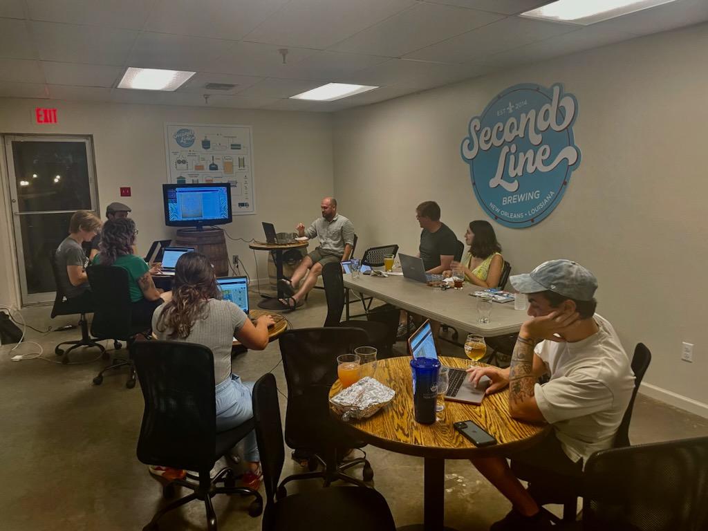
-
Newsletter: It's already May... and there's a lot to say!
Hello! Even though it feels like things have been moving slowly, if I wait months between newsletters I suppose there is a actually a lot to report. So here’s a quick summary, with more detail info below. Also, remember to reply directly to this email to get in touch with me, and there is an unsubscribe link at the end of this message. Site Updates - New content: Des Moines, Salt Lake City, Brooklyn (part of it, anyway), Burlington, and more! READ MORE → -
Newsletter: New Year New Polish
I’m finally ready to send out an update about oldinsurancemaps.net… it’s been many months so I apologize for that, but I promise it’s worth the wait! Before going further, a few quick points: I added a map viewer for each city: oldinsurancemaps.net/viewer/baton-rouge-la (other cities follow this same url pattern) New, more robust, documentation, FAQ, and blog site: about.oldinsurancemaps.net This is now a proper newsletter that you can subscribe/unsubscribe to (if you have an account on the site you are subscribed but can still unsubscribe and retain your account). READ MORE → -
Almost all systems are go!
Near the end of the pilot project the platform was starting to bog down, but I still had to use the tools myself to prepare the content for transfer to LSU Atlas (which has been the plan all along). So, I decided to take evasive action and incrementally (but significantly) restructure it. This took a while, and though I’m not 100% done with the work, most of the important stuff is done and the preparation/split, georeference, and trim operations are now back to working. READ MORE →